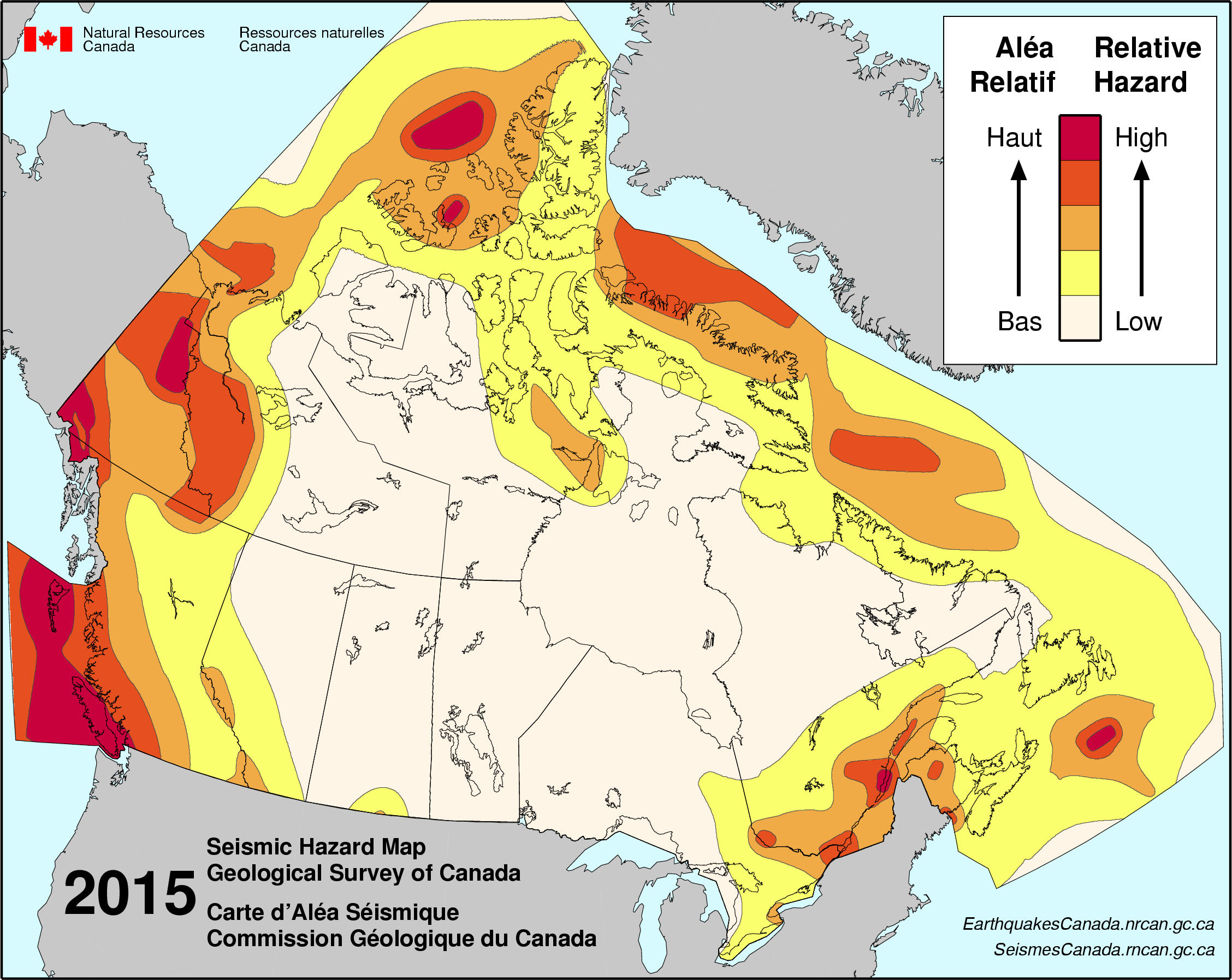
Friday, September 22, 2023

Week 5: Volcanoes

Volcanoes in Canda

    The "Ring of Fire," which some also call the Circum-Pacific Belt, runs along many different country's paths along the Pacific Ocean. Unbeknownst to many Canadians, it also runs along Canada. It's where many active volcanoes and seventy-five percent of Earth's volcanoes are located. In that path are frequent earthquakes. About ninety percent of Earth's earthquakes take place in areas of the "Ring of Fire."
Counting the most dramatic and violent seismic events.

    In Canada, the most recent eruption happened around 150 years ago, in Lava Fork in northwestern British Columbia. However, 2350 years ago, Mount Meager was where Canada's big explosive eruption happened, and the ash layer from this event can currently be found as far in the distance as Alberta. 

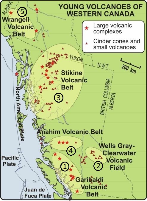
Below is a map of the "Canadian volcanoes that have erupted in the last 1.8 million years" and the five volcanic areas that are potentially active. These areas are located in the Yukon Territory and British Columbia. 

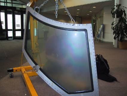
Although Canada does have potentially active volcanoes. Wind-borne ash is the most significant hazard from distant volcanoes such as Mount Baker, located over the Washington State border. If Mount Baker erupted, Canada would likely experience flooding, mudflows in nearby valleys, and ash falls. Which would be very harmful and threaten people with respiratory problems, damage crops, contaminate water, and damage aircraft, as seen in the image below of an aircraft window frosted by volcanic ash, affecting visibility.
                  
Canada has done some things to prepare and help spread awareness: surveys and using tools like seismographs, seismic monitoring stations, GPS instruments or satellite imagery, and Nazko gas monitoring. The Government of Canada has a Get Prepared website for hazards and emergencies.

Sources:


https://chis.nrcan.gc.ca/volcano-volcan/how-comment-en.php


Friday, September 8, 2023

Week 3: Earthquakes

EARTHQUAKES IN CANADA

    Earthquakes happen all over the world. Depending on where you live, how close of proximity you are to the faults will determine how strong the quake will shake. Canada has about 4,000 earthquakes each year. Although most are relatively small. At least nine earthquakes with a magnitude greater than 7 have occurred in the last 100 years. Although there are several fault lines, the three major ones are the Intermountain Seismic Belt, the Queen Charlotte Fault, and the New Madrid seismic zone. The Queen Charlotte Fault being the most famous earthquake zone located in British Columbia in the middle of the Queen Charlotte Fault, and the USA's San Andreas Fault is where the Cascadia Subduction Zone is. The reason for its fame and importance is because in that zone the Juan De Fuca Plate is creeping underneath the North American Plate, and that fault line is stuck. And because of the pressure that is slowly building, the reality is that it will, in due course, pop which will cause "the big one" (a very large earthquake) in British Columbia and California.
 
Canada's seismic hazard map below shows where the relative hazards are and which parts of Canada have higher risks of feeling the shakes and causing more damage.


huihTYTThey SoSources
   The country has implemented various mitigation plans. The picture above is the seismic hazard model "Canada's 6 Generation," was developed for the 2020 National Building Code of Canada (NBCC2020) to generate seismic design values. It's a guide to help guide them where to design and construct buildings that are the most earthquake-proof they can possibly create. It's a version from the Generation 5 seismic source model, which now includes the Leech River Valley Devil's Mountain faults close by Victoria, updates for the deep in-slab earthquakes under the Straits of Georgia, and also increased to match an enhanced paleoseismic record for the rate of Cascadia megathrusts earthquakes. The Pacific, the Arctic, and the Atlanta are where the earthquakes usually occur next to these three coasts. For that reason, the regions most at risk are British Columbia's coast, St. Lawrence River, Ottawa River Valley, and certain parts of the three northern territories.
    Just announced this year, on January 26, 2023, British Columbia is installing sensors connected to the Earthquake Early Warning (EEW). Up to 50 sensors will be installed and operational by 2024. This is an expansion of the already installed sensors of several hundred by Natural Resources Canada. Once completed, 10 million people living in the most earthquake-prone regions in Canada will get an alert giving them valuable seconds to take action: generally to drop, cover, and hold on. 
"Alerts from the EEW system could also be used by infrastructure safety systems to take action automatically, such as:
 ●        Triggering trains to slow down
 ●        Stopping traffic from driving onto bridges or into tunnels
 ●        Diverting incoming air traffic
 ●        Allowing surgeons to stop surgery
 ●        Closing gas valves 
 ●        Opening fire hall and ambulance bay doors"
    There is an emergency alert system tool called Alert Ready that delivers important alerts through radio, television, LTE-connected, and compatible wireless devices, which can be potentially life-saving. Canada's National Public Alerting System (NPAS), shown below, has the power to rapidly warn the public of fast-approaching or unfolding hazards to life to emergency management organizations across the country.  

Sources:


Friday, September 1, 2023

Internal Structure of Earth and Plate Tectonics

 PLATE TECTONICS IN CANADA

A
SEPTEMBER 1, 2023

    Canada is located on the North American tectonic plate's northern part, between the Pacific (on the west) and Eurasian (on the east) plates. It is able to be part continental (North America) and part oceanic (Atlantic Ocean) lithosphere. It's a convergent (subduction) oceanic-continental plate boundary. The reason for knowing such facts about the boundaries of a country's plate tectonic is because it is, in some way, related to the natural geological hazards that have happened and will happen in the future. Knowing exactly where such events like volcanoes and earthquakes will occur is helpful to try to minimize the damage the part of the country will experience.


     The Cascadia Subduction Zone is located in the Pacific Northwest (northern CA, OR, WA, and southern BC), a tectonic boundary of 1,300 km long betwixt the Juan de Fuca and west of the Gorda oceanic plates and the continental plate to the east of North America. It's part of Earth's "Ring of Fire" formed by subduction zone processes as tectonic plates collide and pass each other. The Cascadia region is tectonically active. From mid-Vancouver Island to the Juan de Fuca Plate in northern California, it's subducting beneath the North American Plate. Continually move in the direction of one another and "get stuck" when they make contact. A megathrust earthquake occurs when the strain accumulation exceeds the rubbing between the two plates. They mainly happen offshore. One way to know is that it kills vegetation. Underwater landslides off the continental shelf into the deep ocean are caused by megathrust earthquakes. The British Columbia coast area exposed to the open Pacific is at risk of damaging tsunami waves thrusting the movement of megathrust earthquakes.


Below is a video of the Keyhole Hot Springs in British Columbia, Canada. This is a probable outcome caused by a type of volcanic activity. These hot springs are created when the earth's crust heats the groundwater. It then rises to ground level and, at times, is heated by magma.


Sources:


//www.usgs.gov/centers/pcmsc/science/cascadia-subduction-zone-marine-geohazards


https://earthhow.com/north-american-plate/
https://earthhow.com/north-american-plate/https://earthhow.com/north-american-plate/

Week 16: Final Hazards Report

  Two Most Common Dangerous Natural Hazards in Canada     Canada experiences many natural hazards, but earthquakes and floods are the two mo...