Thursday, December 14, 2023

Week 16: Final Hazards Report

 Two Most Common Dangerous Natural Hazards in Canada

    Canada experiences many natural hazards, but earthquakes and floods are the two most common that threaten people. Earthquakes may be the most dangerous, and floods may cause the most property damage. Canada experiences about 5,000 earthquakes a year. Some sensitive monitoring equipment reports 1,400 earthquakes annually; more than 50 are strong enough to be felt. Floods occur throughout the year and can occur in any region, countryside, or city. The most frequent natural hazard floods are estimated to cost 2.9 billion annually for residential flooding. There are about 1.5 million households at high risk, according to the Insurance Bureau of Canada. Understanding why they occur and how to mitigate those hazards is essential.

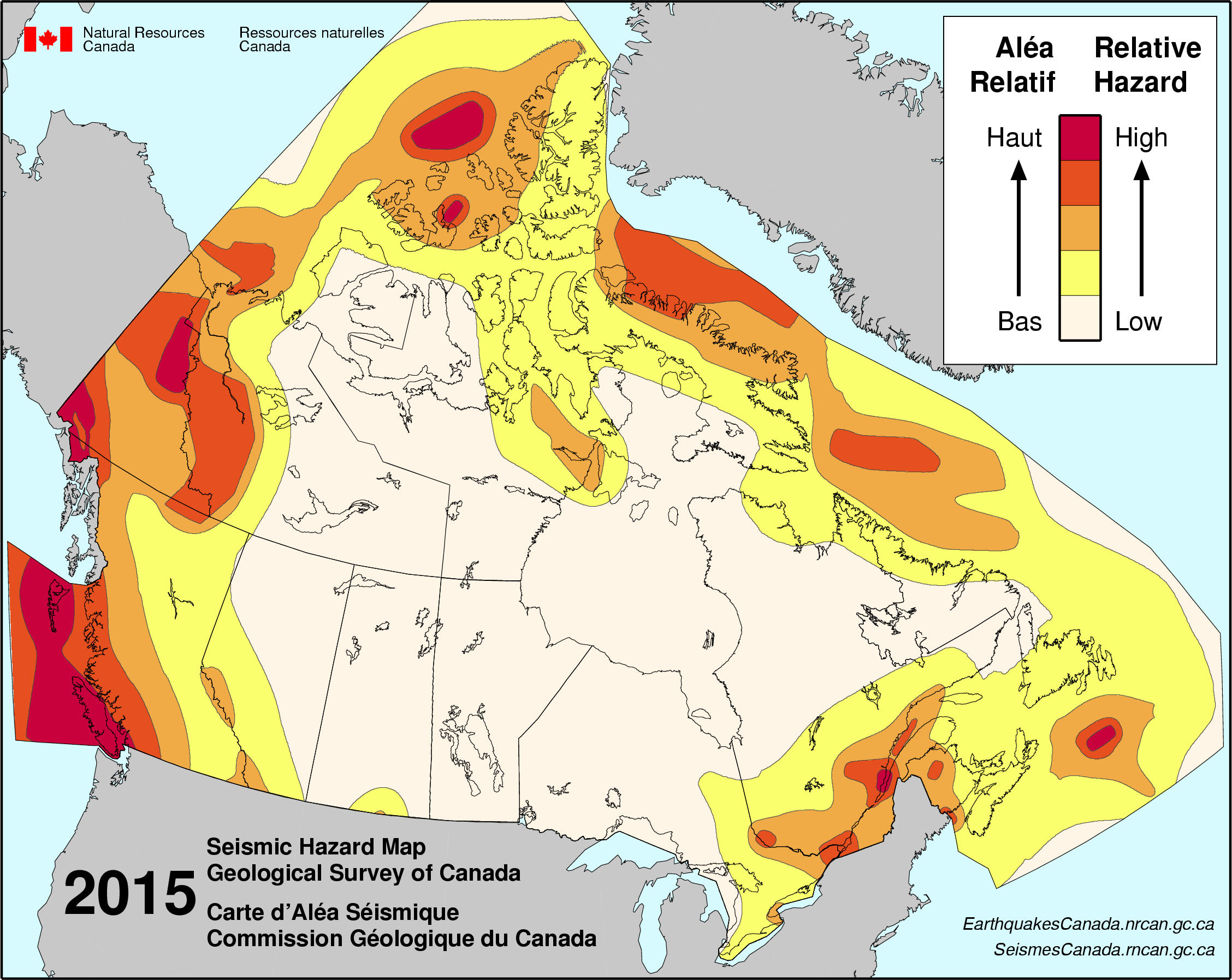
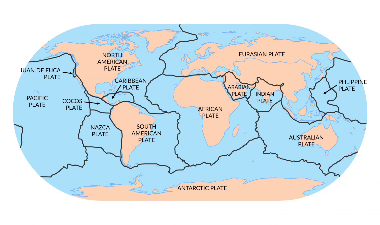
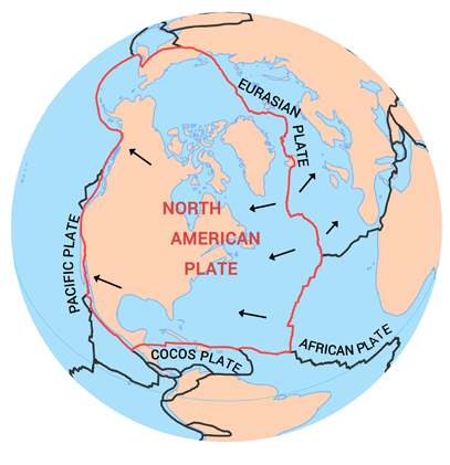
    Earthquakes are caused by the activity of tectonic plates. They are most common along the three coasts: the Atlantic, the Arctic, and the Pacific. This puts regions of the coast of the St. Lawrence River, the Ottawa River valley, British Columbia, and certain sections of the three northern territories at the highest risk. Although there are several fault lines, there are three major ones: the Queen Charlotte fault, the Intermountain Seismic Belt, and the New Madrid seismic zone. As explained in one of my earlier blogs on earthquakes, the Queen Charlotte fault is the most famous because of its location. Here's some relevant and vital information from my prior post, "located in British Columbia in the middle of the Queen Charlotte Fault, and the USA's San Andreas Fault is where the Cascadia Subduction Zone is. The reason for its fame and importance is because in that zone the Juan De Fuca Plate is creeping underneath the North American Plate, and that fault line is stuck. And because of the pressure that is slowly building, the reality is that it will, in due course, pop, which will cause "the big one" (a very large earthquake) in British Columbia and California."

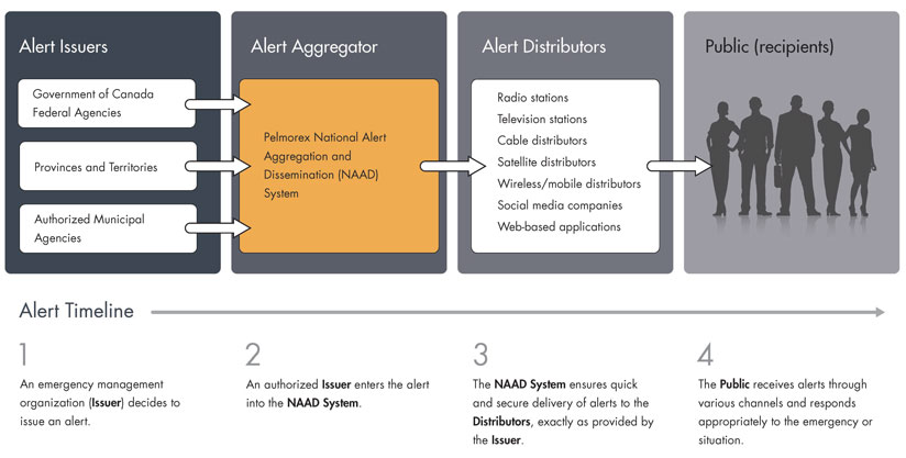
Some mitigation efforts for earthquakes that I would recommend are alert system tools that have been created like:

 "Alerts from the EEW system could also be used by infrastructure safety systems to take action automatically, such as:
 ●        Triggering trains to slow down
 ●        Stopping traffic from driving onto bridges or into tunnels
 ●        Diverting incoming air traffic
 ●        Allowing surgeons to stop surgery
 ●        Closing gas valves 
 ●        Opening fire hall and ambulance bay doors" 

    I would target British Columbia first to help with earthquakes because of the 90% of earthquakes, 60% occur along the coast of British Columbia. Its vulnerability is its location, being near the Queen Charlotte Fault. The USA's San Andreas Fault is located near the Cascadia Subduction Zone. Then, the Juan De Fuca Plate creeps underneath the North American Plate. All these things combined are why I would focus on providing help, such as by spending most earthquake funds on infrastructure emergency alert system tools which would create and incorporate symbols to know which warning alert means so people who speak different languages will automatically know the meaning of the alert without losing precious time to, and educating the public.

    Floods are the most costly, caused by heavy rainfall, the rapid melting of a thick snowpack, ice jams, and the failure of natural or man-made dams. The high-risk floods are located in Canada's biggest cities, such as Fredericton, Vancouver, Calgary, Toronto, Edmonton, and Ottawa-Gatineau. Ten percent are thought to be very high-risk, and within that percentage, there are as many as 1.8 million households. 

Some mitigation efforts I would recommend for floods are programs such as the National Disaster Mitigation Program (NDMP):

"There are four funding streams under the National Disaster Mitigation Program (NDMP):

  • Risk Assessments
    This stream provides funding for the completion of risk assessments to inform flood risks. Risk assessments are the foundational step in disaster mitigation. These risk assessments will identify flood hazards, potential impacts, and community and infrastructure vulnerabilities, as well as the overall flood risk profile for the area.

  • Flood Mapping
    This stream provides funding for the development and/or modernization of flood maps. A flood map identifies the boundaries of a potential flood event based on type and likelihood, and can be used to help identify the specific impacts of a flood event on structures, people and assets.

  • Mitigation Planning
    This stream provides funding for the development and/or modernization of mitigation plans to address flood risks. A comprehensive mitigation plan allows applicants to develop realistic and sustainable mitigation solutions by clearly outlining the plan's objectives, key activities, expected outputs, timelines, and roles and responsibilities.

  • Investments in Non-structural and Small Scale Structural Mitigation Projects
    This stream provides funding for other non-structural and small scale structural disaster mitigation projects. Eligible projects would include actions such as the replacement of storm culverts, or projects that improve flood resilience by proactively preventing or mitigating damages and losses."
    Choosing which part of Canada to help first is a bit harder because there are so many high-risk areas. I would probably choose Toronto because it's the most populous city in Canada; therefore, more lives will be at risk, and infrastructure will be greatly affected, leaving many stranded. So getting help to them would be essential. The picture below shows how bad things can get in Toronto. Besides getting help to people, Another thing that I believe would help this situation besides structural solutions is implementing some regulations concerning non-structural and making sure there are timeframes of when things are done and updated, such as:

  • "regulating land use in the floodplain;
  • floodproofing measures;
  • acquiring property in the floodplain or relocating structures;
  • altering upstream land management practices; and
  • establishing and maintaining flood forecasting and warning systems."
m in less than 3 hours
"A car submerged in flood waters on a Toronto street, next to a streetcar that's also underwater. Radar estimates show some spots received more than 100 mm in less than 3 hours. (@earthisanocean/Twitter)"

    Taking these two dangerous hazards into account when determining where I would construct my home is a bit tricky. Trying to avoid earthquakes is easier since the high-risk areas are located in certain areas, but flooding can affect any region. With that in mind, construction for my home would take place. Since I don't think I can avoid floods, I would concentrate on the stable area of earthquakes that the map above in this post shows.

Sources:


Sunday, November 19, 2023

Week 13: Coastal Hazards

 Coastal Hazards in Canada

    In Canada, coastal erosion happens for many reasons. For example, in Atlantic Canada, waves, tidal action, wind, rain, ice, storm surge, and surface runoff are some reasons for resulting in coastal erosion.  Sea Levels around the Earth are rising, especially in Canada, where in the East, it's sinking, and in the North, the coastal land is lifting. By the year 2100, in areas of Canada, sea levels may rise as much as 175 cm because of the expected melt in Antarctica due to the high emissions. These changes will impact a large population in British Columbia. However, In Atlantic Canada, the sea levels will rise in the most significantly. All three coastlines with indigenous communities are vulnerable to this. "In a 2019 global analysis of population vulnerability to sea level rise and coastal flooding, Kulp and Strauss estimated there to be 320,000 to 600,000 people in Canada who currently occupy land that is subject to sea level rise and coastal flooding." The four Atlantic provinces, New Brunswick, Nova Scotia, Prine Edward Island, Newfoundland, and Labrador, have a coastline of about 38,000 kilometers. British Columbia's coastline is about 26,000 kilometers, and Canada's Arctic coastline is about 162,000 kilometers, a total of about 226,000 kilometers, and exposed to sea level rise. 

Figure 1: Projected relative sea level rise in Canada by 2100
John Clague, an earth sciences professor, said that Fiona produced a lot of permanent. He did, however, mention a lot of Canada's surrounding erosion has to do with the imbalance of sediment. Models show by 2100, there will be a loss of between 6,400 and 14,400 kilometers of sandy beach in Canada. There are studies that show that erosion on Prince Edward Island is at an overall average rate of 0.28 metres per year from 1968 and 2010. 

Canada has the world's longest coastline. It also has developed world-class expertise in managing its country's flood risk. So much so that they have also helped other countries to help them with mitigation efforts for flooding and erosion.
"Canada’s areas of strength in coastal adaptation and flood risk mitigation
  • Industry leading multi-hazard risk assessment and analysis
  • Collaboration with local partners that is mindful of local culture, heritage and economic conditions
  • Capacity building and technical training for local experts
  • Climate change impact and adaptation monitoring systems
  • Award-winning technology including original monitoring and forecasting tools
  • Adaptation program monitoring and evaluation
  • Transparent access to data and information
  • Online decision support systems for flood risk management
  • GIS-based hazard information and mapping
  • Evidence-based, replicable and auditable adaptation solutions"
Sources:


https://ncceh.ca/sites/default/files/inline-images/sea%20level%20rise%20overview%20-%20fig%201.png

Friday, October 13, 2023

Week 7: Mass Wasting

Mass Wasting in Canada

    Thousands of mass wasting, commonly known as landslides, occur yearly in Canada and are a continual and omnipresent threat to Canadians. The eight major types of mass wasting in Canada are rock avalanches, debris avalanches, snow avalanches, rockslides, rock falls, flow slides, debris flows, and slumps. Such notable threats are loss of life, natural resources like timber, mines, fisheries, infrastructure, communication networks, and pipelines, and destruction of roads, homes, and more. The terrestrial landslides account for about $200 to $400 million costs annually by either direct or indirect landslide events. Although a lot of areas of Canada are affected, the high-risk areas are located along vulnerable waterways or in the Canadian Rockies. Since 1771, at least 786 people have died, although most are not deadly. 

The picture below is one of the deadliest mass wasting events.
"The Frank Slide buried part of the mining town of Frank, Alberta, on April 29, 1903. Over 82 million tonnes of limestone rock slid down Turtle Mountain. The landslide is Canada's deadliest in history, killing 73 people. Source: R. Couture, Geological Survey of Canada"


   Unstable areas should be avoided because of its natural and ongoing process, when unstable we can't delay or mitigate mass wasting. It's best to let it go and build in a stable area. The historical landslide maps and database, such as seen in the first image above, can be used by engineers to access risk analysis when building infrastructure like bridges, pipelines, roads, railways, and where to build homes. This will help ensure less fatalities. The Canadian Red Cross website is helpful for people to learn what they can do before, during, and after. Monitoring mass wasting is essential to establish warning systems, to see if conditions have changed at a known slide slope area, or if a debris flow, is actually on its way downslope.
"The Downie Slide above the Revelstoke Resevoir is monitored 24/7 with a range of devices, such as inclinometers (slope-change detectors), bore-hole motion sensors, and GPS survey instruments." An example is seen below where a mechanical device is monitoring near the Checkerboard Slide.

For more information about preventing, delaying, monitoring, and mitigating mass wasting this website is veryhelpful.

Sources:


https://natural-resources.canada.ca/simply-science/canadian-fatal-landslides-mapped/23659


Friday, September 22, 2023

Week 5: Volcanoes

Volcanoes in Canda

    The "Ring of Fire," which some also call the Circum-Pacific Belt, runs along many different country's paths along the Pacific Ocean. Unbeknownst to many Canadians, it also runs along Canada. It's where many active volcanoes and seventy-five percent of Earth's volcanoes are located. In that path are frequent earthquakes. About ninety percent of Earth's earthquakes take place in areas of the "Ring of Fire."
Counting the most dramatic and violent seismic events.

    In Canada, the most recent eruption happened around 150 years ago, in Lava Fork in northwestern British Columbia. However, 2350 years ago, Mount Meager was where Canada's big explosive eruption happened, and the ash layer from this event can currently be found as far in the distance as Alberta. 

Below is a map of the "Canadian volcanoes that have erupted in the last 1.8 million years" and the five volcanic areas that are potentially active. These areas are located in the Yukon Territory and British Columbia. 

Although Canada does have potentially active volcanoes. Wind-borne ash is the most significant hazard from distant volcanoes such as Mount Baker, located over the Washington State border. If Mount Baker erupted, Canada would likely experience flooding, mudflows in nearby valleys, and ash falls. Which would be very harmful and threaten people with respiratory problems, damage crops, contaminate water, and damage aircraft, as seen in the image below of an aircraft window frosted by volcanic ash, affecting visibility.
                  
Canada has done some things to prepare and help spread awareness: surveys and using tools like seismographs, seismic monitoring stations, GPS instruments or satellite imagery, and Nazko gas monitoring. The Government of Canada has a Get Prepared website for hazards and emergencies.

Sources:


https://chis.nrcan.gc.ca/volcano-volcan/how-comment-en.php


Friday, September 8, 2023

Week 3: Earthquakes

EARTHQUAKES IN CANADA

    Earthquakes happen all over the world. Depending on where you live, how close of proximity you are to the faults will determine how strong the quake will shake. Canada has about 4,000 earthquakes each year. Although most are relatively small. At least nine earthquakes with a magnitude greater than 7 have occurred in the last 100 years. Although there are several fault lines, the three major ones are the Intermountain Seismic Belt, the Queen Charlotte Fault, and the New Madrid seismic zone. The Queen Charlotte Fault being the most famous earthquake zone located in British Columbia in the middle of the Queen Charlotte Fault, and the USA's San Andreas Fault is where the Cascadia Subduction Zone is. The reason for its fame and importance is because in that zone the Juan De Fuca Plate is creeping underneath the North American Plate, and that fault line is stuck. And because of the pressure that is slowly building, the reality is that it will, in due course, pop which will cause "the big one" (a very large earthquake) in British Columbia and California.
 
Canada's seismic hazard map below shows where the relative hazards are and which parts of Canada have higher risks of feeling the shakes and causing more damage.


huihTYTThey SoSources
   The country has implemented various mitigation plans. The picture above is the seismic hazard model "Canada's 6 Generation," was developed for the 2020 National Building Code of Canada (NBCC2020) to generate seismic design values. It's a guide to help guide them where to design and construct buildings that are the most earthquake-proof they can possibly create. It's a version from the Generation 5 seismic source model, which now includes the Leech River Valley Devil's Mountain faults close by Victoria, updates for the deep in-slab earthquakes under the Straits of Georgia, and also increased to match an enhanced paleoseismic record for the rate of Cascadia megathrusts earthquakes. The Pacific, the Arctic, and the Atlanta are where the earthquakes usually occur next to these three coasts. For that reason, the regions most at risk are British Columbia's coast, St. Lawrence River, Ottawa River Valley, and certain parts of the three northern territories.
    Just announced this year, on January 26, 2023, British Columbia is installing sensors connected to the Earthquake Early Warning (EEW). Up to 50 sensors will be installed and operational by 2024. This is an expansion of the already installed sensors of several hundred by Natural Resources Canada. Once completed, 10 million people living in the most earthquake-prone regions in Canada will get an alert giving them valuable seconds to take action: generally to drop, cover, and hold on. 
"Alerts from the EEW system could also be used by infrastructure safety systems to take action automatically, such as:
 ●        Triggering trains to slow down
 ●        Stopping traffic from driving onto bridges or into tunnels
 ●        Diverting incoming air traffic
 ●        Allowing surgeons to stop surgery
 ●        Closing gas valves 
 ●        Opening fire hall and ambulance bay doors"
    There is an emergency alert system tool called Alert Ready that delivers important alerts through radio, television, LTE-connected, and compatible wireless devices, which can be potentially life-saving. Canada's National Public Alerting System (NPAS), shown below, has the power to rapidly warn the public of fast-approaching or unfolding hazards to life to emergency management organizations across the country.  

Sources:


Friday, September 1, 2023

Internal Structure of Earth and Plate Tectonics

 PLATE TECTONICS IN CANADA

A
SEPTEMBER 1, 2023

    Canada is located on the North American tectonic plate's northern part, between the Pacific (on the west) and Eurasian (on the east) plates. It is able to be part continental (North America) and part oceanic (Atlantic Ocean) lithosphere. It's a convergent (subduction) oceanic-continental plate boundary. The reason for knowing such facts about the boundaries of a country's plate tectonic is because it is, in some way, related to the natural geological hazards that have happened and will happen in the future. Knowing exactly where such events like volcanoes and earthquakes will occur is helpful to try to minimize the damage the part of the country will experience.


     The Cascadia Subduction Zone is located in the Pacific Northwest (northern CA, OR, WA, and southern BC), a tectonic boundary of 1,300 km long betwixt the Juan de Fuca and west of the Gorda oceanic plates and the continental plate to the east of North America. It's part of Earth's "Ring of Fire" formed by subduction zone processes as tectonic plates collide and pass each other. The Cascadia region is tectonically active. From mid-Vancouver Island to the Juan de Fuca Plate in northern California, it's subducting beneath the North American Plate. Continually move in the direction of one another and "get stuck" when they make contact. A megathrust earthquake occurs when the strain accumulation exceeds the rubbing between the two plates. They mainly happen offshore. One way to know is that it kills vegetation. Underwater landslides off the continental shelf into the deep ocean are caused by megathrust earthquakes. The British Columbia coast area exposed to the open Pacific is at risk of damaging tsunami waves thrusting the movement of megathrust earthquakes.


Below is a video of the Keyhole Hot Springs in British Columbia, Canada. This is a probable outcome caused by a type of volcanic activity. These hot springs are created when the earth's crust heats the groundwater. It then rises to ground level and, at times, is heated by magma.


Sources:


//www.usgs.gov/centers/pcmsc/science/cascadia-subduction-zone-marine-geohazards


https://earthhow.com/north-american-plate/
https://earthhow.com/north-american-plate/https://earthhow.com/north-american-plate/

Friday, August 25, 2023

Cecilia's Geology of Canada

Natural Hazards in Canada


August 25,2023

Welcome!

    Canada is a country in North America. Home to the world's longest coastline, it measures 243,042 km, includes the coasts of offshore islands and the mainland coast, and shares the world's longest international border with the United States, 8,890 km. The most renewable freshwater per person (109,837 m3) is produced by Canada. I'm sure we've all seen the wildfires in Canada that have affected the air quality in parts of the United States in the news just last month. To my surprise, floods are Canada's most frequent natural hazard and occur throughout the year. This is due to man-made dams, the rapid melting of a thick snow pack, ice jams, and heavy rainfall. 
    At times, people tend to confuse the differences between hazards, disasters, and catastrophes. It's important to know that no area in the world is considered hazard-free. A natural hazard is when, for example, a part of an area of land has a mudslide, but nobody lives in that area of land. Therefore, no one is affected. Now, if people live in that land area where a mudslide occurs, it becomes a natural hazard. Because the event (mudslide in this case) becomes a potential threat to property and human life. A natural disaster can apply to different events. Some can be if ten or more people die, the event affects more than one hundred people, they declare a state of emergency, and international assistance is requested. A catastrophe is a massive disaster that will take a long time, usually years, to recover, requiring significant money to be spent to return to normality. 


Sources:

https://www150.statcan.gc.ca/n1/pub/11-402-x/2011000/chap/geo/geo01-eng.htm 


https://www150.statcan.gc.ca/n1/pub/11-402-x/2011000/chap/geo/geo01-eng.htm


Week 16: Final Hazards Report

  Two Most Common Dangerous Natural Hazards in Canada     Canada experiences many natural hazards, but earthquakes and floods are the two mo...